Structured abstract
A potential corridor between alpine pasture and montane forest
The Ämpächli sector above Elm forms a transition zone between open alpine pasture, slope breaks, and montane forest within the broader Sernftal landscape.
To assess whether field-readable landscape features and indirect signs are compatible with use by large carnivores, especially wolves, while avoiding unsupported species confirmation.
Three days of non-invasive field survey across approximately 6.7 km² combined topographic reading, indirect sign documentation, photographic evidence, and regional ecological context.
Large canid-compatible scats with hair and bone fragments, wild ungulate remains, and a coherent linear arrangement of signs were recorded along a natural descent axis.
The evidence supports a cautious interpretation of Ämpächli as a potential large carnivore-compatible movement corridor, but species-level confirmation requires genetic sampling, camera traps, or repeated long-term monitoring.
Résumé structuré
Un corridor potentiel entre alpage et forêt montagnarde
Le secteur d’Ämpächli, au-dessus d’Elm, forme une zone de transition entre alpages ouverts, ruptures de pente et forêt montagnarde. Trois jours de prospection non invasive sur environ 6,7 km² ont permis de documenter des excréments compatibles avec un grand canidé, des restes d’ongulés sauvages et une organisation linéaire des indices. L’interprétation suggère un corridor potentiel pour grands carnivores, mais aucune confirmation spécifique du loup ne peut être avancée sans ADN, pièges photographiques ou suivi répété.
Strukturierte Zusammenfassung
Ein potenzieller Korridor zwischen Alpweiden und Bergwald
Der Sektor Ämpächli oberhalb von Elm bildet eine Übergangszone zwischen offenen Alpweiden, Geländekanten und montanem Wald. Während einer dreitägigen, nicht invasiven Feldbegehung auf etwa 6,7 km² wurden Hinweise dokumentiert, die mit grossen Caniden vereinbar sind, darunter Kot mit Haar- und Knochenfragmenten, Huftierreste und eine lineare räumliche Anordnung der Befunde. Die Interpretation deutet auf einen potenziellen Korridor für Grossraubtiere hin, bleibt aber ohne DNA, Fotofallen oder wiederholtes Monitoring vorsichtig.
Riassunto strutturato
Un possibile corridoio tra pascolo alpino e foresta montana
Il settore di Ämpächli sopra Elm costituisce una zona di transizione tra pascoli alpini aperti, rotture di pendenza e foresta montana. Tre giorni di indagine non invasiva su circa 6,7 km² hanno documentato escrementi compatibili con grandi canidi, resti di ungulati selvatici e una disposizione lineare degli indizi. L’interpretazione suggerisce un possibile corridoio per grandi carnivori, ma senza DNA, fototrappole o monitoraggio ripetuto non è possibile confermare la specie.
Regional context
Wolf recovery, the Kärpf pack, and the Grossraum Elm
The recovery of the wolf in the Swiss Alps is a dynamic ecological process and a sensitive social issue, particularly in valleys where wildlife movement, livestock husbandry, tourism, and mountain infrastructure intersect. In the Canton of Glarus, the Kärpf pack has been publicly documented in the Grossraum Elm, with reproduction confirmed in 2025 through the observation of three pups by the cantonal game wardens.
Against this regional background, a local reading of Ämpächli is relevant because corridors are not only broad cartographic concepts. They are also made of concrete terrain features: ridges, slope breaks, forest edges, funnels, quiet zones, and passages where animal movement becomes more likely.
Contexte régional
Retour du loup, Kärpfrudel et Grossraum Elm
Le retour du loup dans les Alpes suisses constitue un processus écologique dynamique et un sujet social sensible, surtout dans les vallées où se croisent faune sauvage, pastoralisme, tourisme et infrastructures de montagne. Dans le canton de Glaris, la présence du Kärpfrudel dans le Grossraum Elm est documentée publiquement, avec une reproduction confirmée en 2025 par l’observation de trois louveteaux par la garderie de la faune cantonale.
Dans ce contexte, la lecture locale d’Ämpächli est importante car les corridors ne sont pas seulement des lignes sur une carte. Ils sont constitués de reliefs, ruptures de pente, lisières forestières, entonnoirs naturels, zones calmes et passages où les déplacements deviennent plus probables.
Regionaler Kontext
Rückkehr des Wolfs, Kärpfrudel und Grossraum Elm
Die Rückkehr des Wolfs in die Schweizer Alpen ist ein dynamischer ökologischer Prozess und zugleich ein sensibles gesellschaftliches Thema, besonders in Tälern, in denen Wildtierbewegungen, Nutztierhaltung, Tourismus und Berginfrastruktur zusammentreffen. Im Kanton Glarus ist das Kärpfrudel im Grossraum Elm öffentlich dokumentiert; 2025 wurde die Fortpflanzung durch die Beobachtung von drei Welpen bestätigt.
Vor diesem Hintergrund ist die lokale Geländelesung von Ämpächli relevant. Korridore sind nicht nur kartografische Linien, sondern entstehen aus konkreten Landschaftselementen wie Graten, Geländekanten, Waldrändern, Engstellen, Ruhezonen und natürlichen Passagen.
Contesto regionale
Ritorno del lupo, branco del Kärpf e Grossraum Elm
Il ritorno del lupo nelle Alpi svizzere è un processo ecologico dinamico e un tema sociale sensibile, soprattutto nelle valli dove si incontrano movimenti della fauna, attività pastorali, turismo e infrastrutture di montagna. Nel Cantone di Glarona, il branco del Kärpf è documentato pubblicamente nel Grossraum Elm, con riproduzione confermata nel 2025 tramite l’osservazione di tre cuccioli.
In questo contesto, la lettura locale di Ämpächli è importante perché i corridoi non sono solo linee cartografiche. Sono formati da creste, rotture di pendenza, margini forestali, strettoie naturali, zone tranquille e passaggi dove il movimento degli animali diventa più probabile.
Study area
Ämpächli as a structured Alpine transition zone
The surveyed area covers approximately 4 km² above the Sernftal Valley near Elm, Glarus. The site includes exposed alpine ridges and pastures, slope breaks, natural descent lines, and lower montane forest patches. This sequence forms a topographic gradient that may concentrate movement between open feeding areas and sheltered cover.
Seasonal disturbance appears locally reduced during certain periods because of access restrictions, closed infrastructure, and the absence of major hiking routes to prominent summits. Such conditions may increase the value of the area as a nocturnal or low-disturbance movement zone for wild ungulates and carnivores.
Secteur étudié
Ämpächli comme zone de transition alpine structurée
Le périmètre étudié couvre environ 6,7 km² au-dessus de la vallée de la Sernf, près d’Elm. Il comprend des crêtes et alpages exposés, des ruptures de pente, des axes naturels de descente et des fragments de forêt montagnarde. Cette séquence forme un gradient topographique susceptible de concentrer les déplacements entre milieux ouverts et zones de couvert.
Le dérangement saisonnier semble localement réduit à certaines périodes en raison de restrictions d’accès, d’infrastructures fermées et de l’absence de grands itinéraires vers certains sommets. Ces conditions peuvent renforcer la valeur du secteur pour les déplacements nocturnes ou peu perturbés des ongulés et des carnivores.
Untersuchungsgebiet
Ämpächli als strukturierte alpine Übergangszone
Das untersuchte Gebiet umfasst etwa 6,7 km² oberhalb des Sernftals bei Elm. Es umfasst exponierte Alpgrate und Weiden, Geländekanten, natürliche Abstiegslinien und tiefere montane Waldpartien. Diese Abfolge bildet einen topografischen Gradienten, der Bewegungen zwischen offenen Nahrungsflächen und schützender Deckung bündeln kann.
Die saisonale Störung scheint zu bestimmten Zeiten lokal reduziert zu sein, unter anderem durch Zugangsbeschränkungen, geschlossene Infrastruktur und das Fehlen grosser Wanderachsen zu markanten Gipfeln. Solche Bedingungen können den Wert des Gebiets als nächtliche oder störungsarme Bewegungszone für Huftiere und Carnivoren erhöhen.
Area di studio
Ämpächli come zona alpina di transizione strutturata
L’area indagata copre circa 6,7 km² sopra la valle della Sernf, nei pressi di Elm. Comprende creste e pascoli alpini esposti, rotture di pendenza, linee naturali di discesa e nuclei di foresta montana. Questa sequenza forma un gradiente topografico che può concentrare i movimenti tra aree aperte e coperture forestali.
In alcuni periodi il disturbo stagionale sembra localmente ridotto grazie a restrizioni d’accesso, infrastrutture chiuse e assenza di grandi itinerari verso cime importanti. Tali condizioni possono aumentare il valore del settore come zona di spostamento notturna o poco disturbata per ungulati e carnivori.
Methods
Non-invasive field reading and indirect sign survey
Fieldwork was conducted over three days using a non-invasive, multi-layered approach. The survey combined four complementary components:
- Topographic reading: identification of slopes, ridgelines, forest edges, funnels, bottlenecks, and likely movement axes.
- Indirect sign survey: search for scats, tracks, prey remains, marking sites, and other field-readable indicators.
- Photographic documentation: visual recording of relevant signs, including scale where available.
- Spatial mapping: comparison of sign positions with terrain features to assess linearity and possible corridor function.
Méthodes
Lecture non invasive du terrain et recherche d’indices indirects
Le travail de terrain a été conduit sur trois jours selon une approche non invasive et multi-niveaux: lecture topographique, recherche d’indices indirects, documentation photographique et mise en relation spatiale des indices avec les structures du relief.
Methoden
Nicht invasive Geländelesung und indirekte Hinweissuche
Die Feldarbeit erfolgte während drei Tagen mit einem nicht invasiven, mehrschichtigen Ansatz: topografische Geländelesung, Suche nach indirekten Hinweisen, fotografische Dokumentation und räumlicher Abgleich der Befunde mit Landschaftsstrukturen.
Metodi
Lettura non invasiva del terreno e ricerca di indizi indiretti
Il lavoro sul campo è stato svolto per tre giorni con un approccio non invasivo e multilivello: lettura topografica, ricerca di indizi indiretti, documentazione fotografica e confronto spaziale degli indizi con le strutture del rilievo.
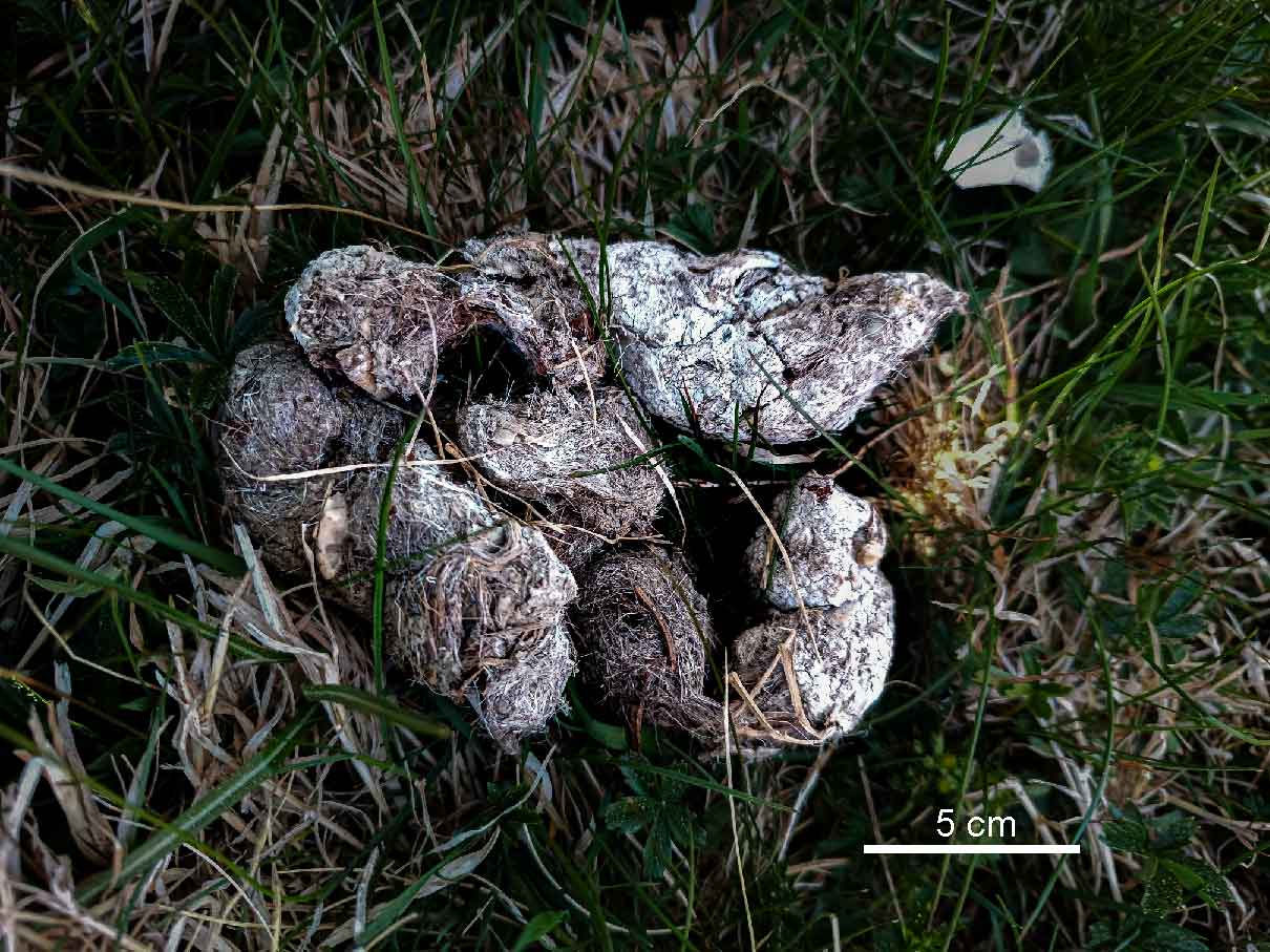
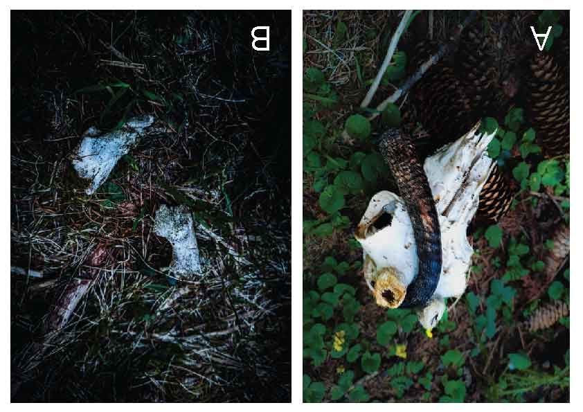
Results
Indirect signs compatible with large canid activity
Several scats morphologically compatible with large canids were recorded along a coherent topographic axis. They showed an elongated and twisted form, high hair content, visible bone fragments, and placement on exposed relief points. Such features may be consistent with territorial marking behavior in wild canids, but they are not diagnostic without genetic analysis.
In adjacent forest patches, wild ungulate remains were documented, including a chamois skull and red deer antler fragments. These remains may result from natural mortality, predation, or scavenging. No direct diagnostic evidence allows attribution to a specific predator.
Résultats
Indices indirects compatibles avec l’activité d’un grand canidé
Plusieurs excréments morphologiquement compatibles avec ceux d’un grand canidé ont été relevés sur un axe topographique cohérent. Ils présentaient une forme allongée et torsadée, une forte présence de poils, des fragments osseux visibles et une position sur des points exposés du relief. Ces critères peuvent correspondre à un comportement de marquage territorial, mais ne sont pas diagnostiques sans analyse génétique.
Dans les zones forestières adjacentes, des restes d’ongulés sauvages ont été observés, notamment un crâne de chamois et des fragments de bois de cerf. Ils peuvent résulter d’une mortalité naturelle, d’une prédation ou d’une activité de charognage.
Ergebnisse
Indirekte Hinweise, die mit grossen Caniden vereinbar sind
Mehrere Kotfunde, morphologisch mit grossen Caniden vereinbar, wurden entlang einer kohärenten topografischen Achse dokumentiert. Sie zeigten eine längliche, gedrehte Form, hohen Haaranteil, sichtbare Knochenfragmente und eine exponierte Lage im Gelände. Diese Merkmale können zu Markierverhalten passen, sind ohne genetische Analyse jedoch nicht beweisend.
In angrenzenden Waldpartien wurden Reste wilder Huftiere festgestellt, darunter ein Gämsenschädel und Rothirsch-Geweihfragmente. Sie können durch natürliche Mortalität, Prädation oder Aasverwertung entstanden sein.
Risultati
Indizi indiretti compatibili con attività di grandi canidi
Diversi escrementi morfologicamente compatibili con grandi canidi sono stati osservati lungo un asse topografico coerente. Presentavano forma allungata e ritorta, elevata presenza di peli, frammenti ossei visibili e collocazione su punti esposti del rilievo. Questi elementi possono essere compatibili con marcatura territoriale, ma non sono diagnostici senza analisi genetica.
Nelle aree forestali adiacenti sono stati documentati resti di ungulati selvatici, tra cui un cranio di camoscio e frammenti di palco di cervo. Possono derivare da mortalità naturale, predazione o necrofagia.
Spatial interpretation
A linear arrangement along a natural descent axis
The recorded signs were not randomly dispersed. They followed a coherent sequence from the upper Ämpächli ridge and forest-pasture ecotone downwards toward a lower forest zone. This pattern is consistent with a natural movement corridor that could be used by wild ungulates, foxes, lynx, and wolves.
The interpretation remains ecological and spatial rather than taxonomic. The corridor hypothesis is based on the alignment of signs, the relief structure, and the functional relationship between open pasture and forest cover.
Organisation spatiale
Une disposition linéaire suivant un axe naturel de descente
Les indices observés ne sont pas répartis au hasard. Ils suivent une séquence cohérente depuis la crête supérieure d’Ämpächli et l’écotone forêt-alpage vers une zone forestière plus basse. Ce schéma est compatible avec un corridor naturel pouvant être utilisé par les ongulés, renards, lynx et loups.
L’interprétation reste écologique et spatiale plutôt que taxonomique. L’hypothèse de corridor repose sur l’alignement des indices, la structure du relief et la relation fonctionnelle entre alpage ouvert et couvert forestier.
Räumliche Interpretation
Lineare Anordnung entlang einer natürlichen Abstiegslinie
Die Hinweise waren nicht zufällig verteilt. Sie folgten einer kohärenten Abfolge vom oberen Ämpächli-Grat und dem Wald-Weide-Übergang hinunter in eine tiefere Waldzone. Dieses Muster ist mit einem natürlichen Bewegungskorridor vereinbar, der von Huftieren, Füchsen, Luchsen und Wölfen genutzt werden könnte.
Die Interpretation bleibt ökologisch und räumlich, nicht taxonomisch. Die Korridorhypothese beruht auf der Ausrichtung der Hinweise, der Reliefstruktur und der funktionalen Beziehung zwischen offenem Alpgebiet und Waldbedeckung.
Interpretazione spaziale
Disposizione lineare lungo un asse naturale di discesa
Gli indizi registrati non erano distribuiti casualmente. Seguivano una sequenza coerente dalla cresta superiore di Ämpächli e dall’ecotono bosco-pascolo verso una zona forestale più bassa. Questo schema è compatibile con un corridoio naturale potenzialmente utilizzato da ungulati, volpi, linci e lupi.
L’interpretazione rimane ecologica e spaziale, non tassonomica. L’ipotesi di corridoio si basa sull’allineamento degli indizi, sulla struttura del rilievo e sulla relazione funzionale tra pascolo aperto e copertura forestale.

Discussion
Corridor compatibility, not species confirmation
The combination of large canid-compatible scat morphology, prey remains, and coherent topographic alignment supports the hypothesis that Ämpächli may function as a movement corridor for large carnivores within the broader Kärpf pack landscape. The sector contains several features compatible with Alpine carnivore movement: compartmentalized relief, discontinuous forest cover, available wild ungulates, and reduced disturbance during certain periods.
Nevertheless, the observations remain preliminary. Scat morphology can overlap between wolves and large domestic dogs, prey remains can result from multiple processes, and a three-day survey cannot establish regularity of use. The scientific value of the report lies in making a cautious, falsifiable hypothesis visible.
Discussion
Compatibilité de corridor, pas confirmation d’espèce
La combinaison d’excréments compatibles avec un grand canidé, de restes de proies et d’un alignement topographique cohérent soutient l’hypothèse qu’Ämpächli puisse fonctionner comme corridor de déplacement pour grands carnivores dans le paysage plus large du Kärpfrudel. Le secteur présente un relief compartimenté, un couvert forestier discontinu, des ongulés sauvages et un dérangement réduit à certaines périodes.
Les observations restent toutefois préliminaires. La morphologie des excréments peut se recouper entre loups et grands chiens, les restes de proies peuvent avoir plusieurs origines, et trois jours d’étude ne permettent pas d’établir une utilisation régulière.
Diskussion
Korridorkompatibilität, keine Artbestätigung
Die Kombination aus mit grossen Caniden vereinbarer Kotmorphologie, Beuteresten und kohärenter topografischer Ausrichtung stützt die Hypothese, dass Ämpächli als Bewegungskorridor für Grossraubtiere innerhalb der weiteren Landschaft des Kärpfrudels fungieren könnte. Der Sektor weist gegliedertes Relief, unterbrochene Waldbedeckung, Wildhuftiere und zeitweise reduzierte Störung auf.
Die Beobachtungen bleiben jedoch vorläufig. Kotmorphologie kann sich zwischen Wolf und grossen Haushunden überschneiden, Beutereste können verschiedene Ursachen haben, und drei Tage Feldarbeit belegen keine regelmässige Nutzung.
Discussione
Compatibilità di corridoio, non conferma di specie
La combinazione di escrementi compatibili con grandi canidi, resti di prede e allineamento topografico coerente sostiene l’ipotesi che Ämpächli possa funzionare come corridoio di movimento per grandi carnivori nel paesaggio più ampio del branco del Kärpf. Il settore presenta rilievo compartimentato, copertura forestale discontinua, ungulati selvatici e disturbo ridotto in alcuni periodi.
Le osservazioni restano tuttavia preliminari. La morfologia degli escrementi può sovrapporsi tra lupo e cane domestico di grande taglia, i resti di prede possono avere cause diverse e tre giorni di indagine non dimostrano un uso regolare.
Limitations
Why caution is essential
| Limitation | Consequence | Needed follow-up |
|---|---|---|
| No genetic sample | Species-level confirmation is impossible. | DNA analysis from fresh scat, hair, saliva, or other suitable material. |
| No camera-trap confirmation | No direct visual record of the responsible species. | Targeted camera-trapping along the corridor axis. |
| Short survey duration | Regularity of use cannot be evaluated. | Repeated surveys across seasons and snow conditions. |
| Alternative explanations | Domestic dog activity, scavenging, or natural mortality cannot be excluded. | Combined sign, genetic, and photographic monitoring. |
Limites
Pourquoi la prudence est essentielle
Aucun prélèvement ADN, aucune confirmation par piège photographique et la courte durée de l’étude empêchent toute confirmation spécifique ou conclusion sur une utilisation régulière. Des explications alternatives restent possibles, notamment activité de grands chiens, charognage ou mortalité naturelle.
Einschränkungen
Warum Vorsicht wesentlich ist
Ohne genetische Probe, ohne Fotofallenbestätigung und aufgrund der kurzen Untersuchungsdauer ist weder eine artspezifische Bestätigung noch eine Aussage zur regelmässigen Nutzung möglich. Alternative Erklärungen wie grosse Haushunde, Aasverwertung oder natürliche Mortalität bleiben möglich.
Limiti
Perché la prudenza è essenziale
L’assenza di campioni genetici, di conferma tramite fototrappole e la breve durata dell’indagine impediscono una conferma specifica o conclusioni sull’uso regolare. Restano possibili spiegazioni alternative, come cani domestici di grande taglia, necrofagia o mortalità naturale.
Recommendations
From provisional interpretation to stronger evidence
Collect fresh scat or hair samples following appropriate protocols and submit them for laboratory analysis.
Place cameras along the ridge-to-forest descent axis to test repeated use by large carnivores and ungulates.
Repeat surveys during snow, low-disturbance, and vegetation periods to assess whether use is occasional or recurrent.
Recommandations
Passer d’une interprétation provisoire à des preuves plus fortes
Les priorités sont le prélèvement génétique d’indices frais, la pose ciblée de pièges photographiques sur l’axe crête-forêt et la répétition saisonnière des prospections afin de tester la régularité d’utilisation.
Empfehlungen
Von der vorläufigen Interpretation zu stärkerer Evidenz
Prioritär sind genetische Proben frischer Hinweise, gezielte Fotofallen entlang der Grat-Wald-Achse und wiederholte saisonale Begehungen, um gelegentliche von regelmässiger Nutzung zu unterscheiden.
Raccomandazioni
Dall’interpretazione provvisoria a prove più robuste
Le priorità sono il campionamento genetico di indizi freschi, l’uso mirato di fototrappole lungo l’asse cresta-foresta e ripetizioni stagionali per distinguere un uso occasionale da uno ricorrente.
Conclusion
A functional landscape hypothesis worth monitoring
The Ämpächli sector exhibits several elements compatible with large carnivore movement in an Alpine transition landscape: a ridge-to-forest topographic sequence, large canid-compatible signs, wild ungulate remains, and a coherent spatial arrangement. These observations support a cautious corridor hypothesis rather than a species-level confirmation.
For NATURASCHUTZ.CH, the value of this report lies in connecting local field observation with transparent scientific caution. The next step is not to overstate the evidence, but to transform the hypothesis into a structured monitoring protocol capable of confirming, refining, or rejecting the interpretation.
Conclusion
Une hypothèse fonctionnelle qui mérite un suivi
Le secteur d’Ämpächli présente plusieurs éléments compatibles avec le déplacement de grands carnivores dans un paysage de transition alpine: séquence crête-forêt, indices compatibles avec un grand canidé, restes d’ongulés et organisation spatiale cohérente. Ces observations soutiennent une hypothèse prudente de corridor, non une confirmation spécifique.
Schlussfolgerung
Eine funktionale Landschaftshypothese, die Monitoring verdient
Der Sektor Ämpächli weist mehrere Elemente auf, die mit Bewegungen von Grossraubtieren in einer alpinen Übergangslandschaft vereinbar sind: eine Grat-Wald-Sequenz, mit grossen Caniden vereinbare Hinweise, Huftierreste und eine kohärente räumliche Anordnung. Diese Beobachtungen stützen eine vorsichtige Korridorhypothese, keine artspezifische Bestätigung.
Conclusione
Un’ipotesi funzionale di paesaggio da monitorare
Il settore di Ämpächli presenta diversi elementi compatibili con il movimento di grandi carnivori in un paesaggio alpino di transizione: sequenza cresta-foresta, indizi compatibili con grandi canidi, resti di ungulati e organizzazione spaziale coerente. Queste osservazioni sostengono un’ipotesi prudente di corridoio, non una conferma specifica.
Sources and public context
References
- Kanton Glarus. Welpen beim Kärpfrudel nachgewiesen. Public newsroom, 4 September 2025.
- Kanton Glarus. Grossraubtiere — News and information page.
- KORA. What is monitoring?
- KORA. Genetics in large carnivore monitoring.
- KORA. Wolf distribution records in Switzerland.