Abstract
A complete case study for adaptive restoration in post-extraction landscapes
Parcel 1988 in Zunzgen is a 14,810 m² former limestone extraction and deposition site that has experienced substantial ecological degradation.
The study integrates drone-based aerial mapping, wildlife monitoring through camera traps, direct observations, plant biodiversity assessment, and structured analysis using Excel.
Restoration strategies are treated as flexible interventions that must evolve according to continuous observation and data-driven insights.
The study advocates the future implementation of NaturaSchutz DB to enhance data management and long-term monitoring.
This study presents a detailed exploration of adaptive restoration techniques applied to Parcel 1988, a 14,810 square meter site in Zunzgen (BL), Switzerland, which has experienced substantial ecological degradation due to historical limestone extraction and the deposition of construction materials. Utilizing a multidisciplinary approach, the research integrates drone-based aerial mapping, wildlife monitoring through camera traps, and plant biodiversity assessment using AI-driven tools. Data were meticulously collected and analyzed using Excel, revealing the critical role of adaptive management in ecological restoration. This approach emphasizes flexibility and responsiveness, allowing restoration strategies to evolve based on continuous observation and data-driven insights. The study also advocates for the future implementation of a specialized database system, NaturaSchutz DB, to enhance data management and support long-term monitoring efforts. By providing practical recommendations and a scalable restoration model, this research contributes valuable knowledge to the field of ecological restoration and offers a framework that can be adapted to similar sites in Baselland as well as other cantons.
Keywords: Adaptive restoration, quarry rehabilitation, ecological restoration, biodiversity, Parcel 1988, Zunzgen, data management, drone mapping, AI-driven species identification, NaturaSchutz DB, conservation strategies, long-term monitoring, ecosystem resilience.
Introduction
Restoration must respond to the ecological reality of each site
The extraction of raw materials from quarries is crucial for the construction and industrial sectors, yet it often results in significant ecological disruption. These activities lead to vegetation loss, wildlife habitat destruction, and alterations to local hydrological systems, leaving lasting impacts on the landscape. This is particularly evident at sites like Parcel 1988 in Zunzgen (BL), Switzerland, where extensive limestone extraction and the deposition of construction materials have caused marked ecological degradation. As these extraction sites are gradually phased out of active use, the need for their ecological restoration becomes increasingly critical. Such restoration not only seeks to mitigate the environmental damage caused by quarrying but also aims to enhance biodiversity and reestablish ecosystems that provide essential ecological services (Clewell & Aronson, 2013).
Ecological restoration, also known as nature restoration, involves assisting the recovery of ecosystems that have been degraded, damaged, or destroyed. The goal is to return an ecosystem as close to its natural state as possible, considering the conditions before disturbance. Restoration efforts are crucial for reestablishing ecological integrity, enhancing resilience, and ensuring long-term sustainability. By restoring the natural structure, function, and composition of ecosystems, these efforts revive essential processes like nutrient cycling and hydrology. This approach plays a vital role in reversing biodiversity loss, combating climate change, and securing ecosystem services upon which human societies depend, such as clean water, fertile soil, and climate regulation (United Nations, 2021).
However, the growing demand for ecological restoration has outpaced the development of traditional techniques, often leading to the application of standardized practices that do not fully account for local ecological contexts. In regions such as Basel-Landschaft (Baselland) and other cantons in Switzerland, common restoration practices include creating brush piles to serve as refuges for small animals, constructing stone piles to provide shelter for reptiles and amphibians, and establishing no-mow zones to encourage plant growth. While these interventions are designed to enhance biodiversity, they often overlook the specific needs of local wildlife and the broader ecological dynamics of the area (Swiss Biodiversity Strategy, 2012).
For instance, the restoration project associated with the new railway line between Liestal and Waldenburg placed piles of stones and wood stumps just a few meters away from a cantonal road and train tracks. Although intended to support small creatures, their proximity to heavily trafficked areas limits their ecological effectiveness. This placement might have been driven more by the goal of achieving green certification—a commendable initiative promoting environmental responsibility—than by a deep understanding of the local environment. Green certification, while valuable, must be implemented with a sense of the local ecological context to truly benefit ecosystems (Holling, 1978).
Existing protocols for quarry restoration often follow a standardized approach, focusing on the creation of specific habitats, such as amphibian ponds or nesting sites for birds, tailored to the geological and landscape characteristics of the site. For instance, standard protocols in Switzerland emphasize the importance of considering the dynamic, fluvial-like nature of extraction sites, which can foster a rich diversity of species (Swiss Biodiversity Strategy, 2012). However, while these protocols provide a useful framework, they are not without limitations. Their systematic, one-size-fits-all approach can be too rigid, failing to account for the unique and dynamic ecological conditions of each site. This rigidity is particularly problematic in environments like Parcel 1988, where natural succession, weather variability, and ongoing human activity can rapidly alter ecological contexts. Furthermore, the effectiveness of these protocols is often compromised by insufficient monitoring, which is crucial for ensuring that restoration efforts achieve their intended ecological outcomes (Clewell & Aronson, 2013).
Challenges in ecological restoration are not confined to Switzerland. Similar issues have arisen globally, often with more significant impacts. A notable example is the reintroduction of bears from Slovenia to the Pyrenees, an initiative undertaken years ago to restore the brown bear population. Despite the good intentions, this project highlighted the complexities of introducing a species into a new environment. The Slovenian bears, which are smaller and have different behavioral patterns, were introduced into the more open, human-impacted landscapes of the Pyrenees, leading to conflicts with local farmers and difficulties in adapting to different climate and environmental conditions (Linnell, Swenson, & Andersen, 1997). Some of these bears have since migrated towards urban areas in search of food, leading to new conflicts with humans and raising safety concerns (Linnell, Swenson, & Andersen, 1999).
Despite the lessons from such experiences, similar approaches continue to be pursued, albeit with evolving challenges. A current example is the reintroduction of the Grand Tétras in the Vosges Mountains. Against scientific recommendations, political decisions were made to reintroduce Grand Tétras from Norway into the Vosges, where the species struggles due to warming temperatures and habitat loss. The Norwegian birds, adapted to colder climates, face significant challenges in the warmer, less suitable environment of the Vosges, raising concerns about the long-term viability of this reintroduction effort (Ménoni, Schatz, & Bollmann, 2020).
These examples underscore the need for what can be termed Adaptive Nature Restoration—an approach that goes beyond standardized methods to account for the specific ecological, behavioral, and climatic needs of species within their unique environments. Adaptive Nature Restoration emphasizes the importance of tailoring restoration strategies to the local context, continuously learning from past and present interventions, and being responsive to the dynamic nature of ecosystems. This approach is particularly relevant to the restoration of quarry sites like Parcel 1988, where the ecological conditions are constantly changing due to natural succession, weather variability, and ongoing human activities (Holling, 1978).
Study site and objectives
Parcel 1988 as a complex restoration mosaic
This study focuses on Parcel 1988 as a case study for adaptive and integrative restoration. The site, owned by RUEPP AG, covers approximately 14,810 square meters and has been heavily impacted by industrial activities, resulting in significant ecological disturbances. The parcel's geographical configuration, extending about 242 meters from north to south with varying widths, presents both challenges and opportunities for restoration. These geographical features influence both the development possibilities and the restoration strategies required. Historically, Parcel 1988 has been used not only for limestone extraction but also as a deposition site for construction materials, leading to a noticeable discontinuity in forest cover and a fragmented landscape bordered by agricultural fields, a cantonal road, and forested areas. The topography of the site is characterized by three distinct levels, each exhibiting varying degrees of ecological degradation, complicating the restoration process.
The primary objective of this study is to evaluate and apply adaptive and integrative restoration techniques at Parcel 1988, guided by several specific goals. These include assessing the current ecological state of the site, implementing adaptive management strategies to restore ecological functions and enhance biodiversity, documenting the restoration process and outcomes through detailed data collection and analysis, and proposing future directions for restoration projects. These goals are informed by the need for a more responsive, data-driven approach to ecological restoration, one that moves beyond the limitations of standard protocols to address the unique ecological challenges presented by Parcel 1988.
The objectives of this study can be summarized as follows:
- Assess the current ecological state of Parcel 1988.
- Implement adaptive management strategies to restore ecological functions and enhance biodiversity.
- Document the restoration process and outcomes through detailed data collection and analysis.
- Propose future directions for similar restoration projects.
- Develop a scalable, data-driven approach that moves beyond standard protocols.
An integrative restoration approach is proposed to address the shortcomings of existing restoration models, emphasizing a broader, ecosystem-wide perspective rather than focusing narrowly on specific species or habitats. This approach seeks to gain a comprehensive understanding of the existing ecosystem and its potential for recovery by collecting extensive data on biodiversity levels, assessing the suitability of identified high-potential zones, and developing adaptive management strategies based on ongoing monitoring and analysis. Such an approach is particularly important in the context of Parcel 1988, where the site’s dynamic nature and complex topography require a flexible, responsive strategy that can adapt to changing ecological conditions.
The scientific approach adopted in this project is rigorous and multidisciplinary, incorporating various methods to gather data on the fauna, flora, and environmental conditions of the quarry. Parcel 1988 is divided into three levels, each with distinct ecological characteristics. The data collection methods include surveillance with camera traps to monitor wildlife activity, analysis of animal tracks, recording of bird sounds, and drone-based aerial mapping. Additionally, plant, tree, and flower species are identified using the Flora Incognita app, which provides accurate species identification through photographic analysis. This AI-driven tool is essential for documenting and monitoring plant biodiversity within the site, particularly in areas without internet access. Together, these methods provide detailed and accurate data on the biodiversity and ecological evolution of the restored quarry, contributing to the development of a scalable, adaptive restoration model that can be applied to similar projects worldwide.
In conclusion, the adaptive restoration of Parcel 1988 represents a critical step forward in developing more effective and responsive ecological restoration strategies. By moving beyond the limitations of standard protocols and embracing a flexible, data-driven approach, this study aims to restore the site’s ecological functions and enhance its biodiversity. The integrative restoration approach proposed in this study offers a scalable model that can be adapted to similar projects worldwide, contributing to the growing body of knowledge on ecological restoration and providing valuable insights for future conservation efforts.
Materials and methods
Drone mapping, field monitoring, AI tools, and adaptive data management
| Method | Purpose | Restoration value |
|---|---|---|
| Drone-based mapping | High-resolution spatial reading of topography, vegetation, access routes, and structural discontinuities. | Supports sector definition and spatial planning. |
| Wildlife monitoring | Camera traps, direct observations, bird sound recordings, and field traces. | Documents species presence, detection patterns, and habitat use. |
| Plant biodiversity assessment | Identification of trees, flowers, and vegetation patterns using field photography and Flora Incognita. | Tracks succession, vegetation character, and habitat development. |
| Structured data analysis | Observation records, sector comparisons, species richness, abundance summaries, and diversity indices. | Supports adaptive decision-making and long-term monitoring. |
Site mapping and subdivision
The effective restoration of Parcel 1988, a former limestone quarry located in Zunzgen (BL), Switzerland, necessitated a detailed understanding of the site's physical and ecological characteristics. To achieve this, a DJI Mavic Pro (version 1) drone, known for its precision and reliability, was deployed to capture high-resolution aerial imagery. This drone, equipped with a 12MP 1/2.3-inch CMOS sensor, was capable of recording 4K video at 30fps and taking still images at a resolution of 4000 × 3000 pixels. Such capabilities were essential for obtaining the detailed spatial data required to map the complex topography and ecological zones of the site.
The aerial mapping was conducted over two meticulously planned flight sessions, each following an S-shaped flight pattern to ensure comprehensive and systematic coverage of the entire parcel. This flight pattern was chosen to maximize overlap between images, which is crucial for accurate stitching and analysis (Turner et al., 2015).
The first flight, executed at an altitude of 119 meters, aimed to capture a broad overview of the entire parcel. This lower resolution, wide-area mapping provided crucial insights into the large-scale features of the site, such as the distribution of major vegetation types, the extent of bare ground, and the layout of the terrain. The data from this flight formed the foundation for subsequent detailed analyses and was critical for understanding the broader spatial context of the restoration site.
Following the initial survey, a second flight was carried out at an altitude of 31 meters to acquire higher-resolution images. This flight was designed to capture finer details of the site, including specific vegetation patterns, the microtopography of the quarry floor, and small-scale ecological features such as rock piles or water accumulation areas. The S-shaped flight pattern was again employed to ensure that no areas were missed and that the images could be effectively stitched together. A total of 66 images were captured during these flights, ensuring comprehensive coverage of the parcel.
The raw images were processed using Rawtherapee 10.5, a powerful open-source image editing software designed for high-quality image processing (RawTherapee Development Team, 2020). Adjustments were made to enhance clarity, contrast, and color balance, ensuring uniformity across the dataset. This standardization was vital for producing a consistent and accurate map that could be used for both qualitative and quantitative analyses. The processed images were then stitched together using the Autostitch program, an advanced tool designed for creating panoramic images (Brown & Lowe, 2007). The stitching process was carefully configured, with parameters such as a final map height of 26,200 pixels, multiband blending set to "multiband: 3," and maximum memory allocation of 4.00 GB to ensure the highest possible image quality. The resulting high-resolution map was stored in the project’s digital database and served as a key resource for guiding and documenting the restoration process.
Wildlife monitoring techniques
To assess the presence, distribution, and behavior of wildlife within Parcel 1988, a comprehensive monitoring strategy was implemented, utilizing state-of-the-art camera trap technology. The Suntekcam HC940 camera traps were selected for their advanced features and robustness in outdoor environments (Suntekcam, 2021). These cameras were strategically positioned across various sectors of the site, including forested areas, open fields, and rocky outcrops, to capture a diverse range of habitats and maximize the likelihood of detecting different wildlife species.
Each camera trap was equipped with a high-resolution sensor capable of capturing images at up to 36MP and recording 4K video at 30fps. The fast trigger speed of 0.3 seconds ensured that even the swiftest animals were captured in the frame, providing valuable data on species presence and activity patterns. The adjustable Passive Infrared (PIR) sensors, with a detection range extending up to 20 meters, allowed for the precise calibration of the traps to specific environmental conditions, such as varying vegetation density and terrain features (Meek et al., 2014).
To facilitate continuous monitoring, particularly during nocturnal hours, the camera traps were outfitted with 56 infrared LEDs. These LEDs provided night vision capabilities without emitting visible light, thereby minimizing disturbance to the wildlife and ensuring natural behavior was recorded (Suntekcam, 2021). The traps were powered by high-capacity 10,000mAh built-in lithium batteries, offering up to six months of operation without the need for maintenance, a feature critical for long-term monitoring in remote areas. The IP65 rating of the traps ensured they were resistant to both dust and water, making them highly suitable for the varied and sometimes harsh environmental conditions of Parcel 1988.
Data collected from the camera traps were stored on SD cards, with periodic retrieval and backup to ensure data integrity. For selected traps, 4G connectivity allowed for the remote transmission of data, facilitating real-time monitoring and quick adjustments to trap placement if necessary. The SuntekCam app was used to manage and analyze the data remotely, providing a user-friendly interface for reviewing images and videos and making informed decisions about the ongoing monitoring strategy.
Direct observations and camera use
In addition to the automated wildlife monitoring provided by the camera traps, direct observations were conducted using high-performance cameras to capture detailed images and videos of wildlife at various distances. The Sony RX10iv and Nikon COOLPIX P1000 cameras were chosen for their exceptional zoom capabilities, image quality, and versatility in field conditions.
Field observations focused on key species such as lizards, insects, and birds, with particular attention paid to their activity during peak periods, for example midday for reptiles and early morning for birds. Detailed notes were recorded alongside the photographic data, capturing information on species behavior, interactions, and environmental conditions at the time of observation. This combination of high-resolution imagery and detailed observational data provided a rich dataset for analyzing the biodiversity and ecological dynamics of Parcel 1988.
Bird sound recording and processing
Given the importance of avian species as indicators of ecological health, bird vocalizations were systematically recorded to assess the diversity and abundance of bird species within Parcel 1988. Recordings were conducted during the early morning hours, from 8:00 AM to 10:00 AM, when bird activity is typically at its peak. This timing was carefully selected to align with work schedule constraints while maximizing the likelihood of capturing a representative sample of the avian community.
To analyze the recorded bird sounds, the study utilized BirdNET and Merlin Bird ID software, both developed by the Cornell Lab of Ornithology and recognized for their accuracy and reliability. BirdNET, an AI-powered tool, employs deep learning algorithms to identify bird species based on their songs and calls. With a database capable of recognizing over 3,000 species globally, BirdNET provided a powerful means of identifying species even in dense vegetation or low-visibility conditions, where visual confirmation might be difficult (Kahl et al., 2021).
Merlin Bird ID complemented BirdNET by offering both sound and visual identification capabilities. The software's extensive database includes regional and seasonal data, which enhances its accuracy in identifying species specific to the local context of Parcel 1988. The ability to operate offline was particularly beneficial in areas with limited internet connectivity, allowing for real-time identification of species during fieldwork (Van Horn & Iliff, 2020). The combined use of these tools ensured that the bird species present within Parcel 1988 were accurately and comprehensively documented, providing critical data for assessing the site’s avian biodiversity.
The recorded bird sounds were further processed using Audacity, an open-source audio editing software, to enhance the volume and clarity of the recordings. This step was essential for ensuring that all bird vocalizations were captured at a consistent volume, facilitating accurate species identification and analysis (Audacity Team, 2020).
Plant, tree, and flower recognition
The identification and documentation of plant biodiversity within Parcel 1988 were conducted using the Flora Incognita app, an advanced AI-driven tool designed for the automatic identification of vascular plant species (Mäder et al., 2021). This app is capable of identifying over 16,000 species, making it an invaluable resource for ecological studies focused on biodiversity assessment and monitoring.
Researchers utilized Flora Incognita to photograph various plant parts, including leaves, flowers, and stems. The app’s deep neural networks processed these images, considering factors such as the plant’s growth form, phenological stage, and environmental context to provide accurate species identifications. The app’s adaptive learning algorithms allowed it to improve its accuracy over time, becoming increasingly effective at identifying the species present within the site.
Flora Incognita also provided comprehensive fact sheets for each identified species, offering detailed information on characteristics, distribution, ecology, and protection status. These fact sheets were crucial for understanding the ecological role of each species within Parcel 1988 and for monitoring changes in plant diversity over time. The app’s offline functionality enabled continuous data collection in remote areas without internet access, with data syncing and processing occurring once connectivity was restored. The systematic use of Flora Incognita in this study ensured that the plant biodiversity within Parcel 1988 was thoroughly documented, forming a solid foundation for evaluating the success of the restoration efforts.
Drawing and sketching techniques
To visually document specific aspects of the restoration process, including the layout of vegetation and the spatial distribution of key ecological features, DrawingBotV3 version 1.6.19 was utilized. This software is designed to create detailed sketches and diagrams, allowing researchers to visualize complex spatial data and ecological relationships in an accessible format. The sketches produced by DrawingBotV3 were used to complement photographic data and provide a clear representation of the restoration site’s evolving landscape.
DrawingBotV3’s tools were particularly valuable for creating annotated diagrams that highlighted the locations of key interventions, such as the placement of rock piles or the development of water accumulation areas. These sketches were integrated into the project’s documentation to provide a comprehensive visual record of the restoration efforts, aiding in both analysis and communication of the project’s progress.
Data collection and analysis using Excel
The diverse and complex datasets generated from wildlife monitoring, plant identification, and other observational methods were systematically recorded and managed using a specialized database designed in Microsoft Excel. Excel was chosen for its versatility, user-friendly interface, and robust data management capabilities, making it an ideal tool for organizing and analyzing large volumes of ecological data specific to the needs of this study.
- Data organization: Data were meticulously organized into separate worksheets corresponding to different sectors of Parcel 1988. Each entry was documented in detail, including records of species identification by both their Latin names and their common names in English, German, and French, the languages used in Switzerland. The database also categorized the type of observation, for example birds, amphibians, reptiles, excrements, and footprints, the precise location within the sector, such as street, side road, or single trail, and substrate type, such as wood, stone, or concrete.
- Additional attributes: The database also included fields for recording the developmental stage of the observed species, such as adult or young, migration behaviors, and standardized conservation status. Further, it logged any special conservation programs related to the species, along with associated activities. Each observation was also linked to corresponding proof, such as audio recordings, photos, or videos, and included details on the identification program used, for example BIRDS NET or FLORA Incognita, or whether the identification was performed by a user.
- Data analysis: Excel’s powerful analytical tools were employed to perform statistical analyses, such as calculating species abundance and diversity indices. The database was designed to allow easy cross-referencing and retrieval of data, enabling researchers to track changes in biodiversity and ecological conditions over time. The structured data facilitated the generation of visual representations, including charts and graphs depicting trends in species populations, distribution patterns, and other key ecological indicators. These visualizations were instrumental in interpreting the data and informing adaptive management strategies, ensuring that restoration efforts were responsive to the evolving ecological conditions within Parcel 1988.
This comprehensive and standardized approach to data collection and management ensures that all relevant information is captured systematically, enabling a detailed and nuanced understanding of the ecological dynamics at play. This database also provides a solid foundation for future analysis, contributing to the ongoing success of adaptive restoration efforts at Parcel 1988.
In addition to its data management and analysis capabilities, Excel was also used to develop a preliminary framework for the proposed NaturaSchutz DB system. This dedicated database system, envisioned as a tool for streamlining restoration data management, will build on the data structures and analytical processes established in Excel. NaturaSchutz DB is intended to enhance the scalability of the restoration model, allowing it to be adapted and applied to similar projects in other locations. The development of this database system represents a forward-thinking approach to long-term ecological monitoring and data-driven conservation strategies.
Integration of adaptive management techniques
A key aspect of this study was the implementation of adaptive management techniques, which emphasized flexibility and responsiveness in restoration strategies. Adaptive management is an iterative process that involves continuous monitoring, data collection, and the ability to adjust management actions based on real-time feedback and observed outcomes. This approach is particularly well-suited to dynamic environments like Parcel 1988, where ecological conditions can change rapidly due to factors such as weather variability, natural succession, and ongoing human activity.
The adaptive management process in this study involved regular reviews of the collected data, followed by iterative modifications to the restoration strategy as necessary. For example, camera trap placements were adjusted to improve wildlife detection rates, and specific areas of the site were prioritized for intervention based on emerging data trends. These adjustments were guided by the principle of maximizing ecological benefits while remaining responsive to the site’s changing conditions.
The integration of adaptive management techniques was further supported by the proposed development of the NaturaSchutz DB system, which will facilitate the ongoing collection, storage, and analysis of restoration data. This system is designed to be scalable and adaptable, allowing it to be customized for use in other restoration projects with different ecological contexts. By enabling real-time data analysis and informed decision-making, NaturaSchutz DB will play a crucial role in ensuring the long-term success and sustainability of restoration efforts at Parcel 1988 and beyond.
Results
Site mapping, ecological subdivision, biodiversity patterns, and temporal trends
1. Site mapping and subdivision
The initial phase of the restoration process for Parcel 1988 involved creating high-resolution maps using advanced drone technology. This approach was essential to address the limitations of outdated imagery available on platforms like Google Earth. The deployment of drone technology enabled the capture of detailed aerial images, providing an accurate and up-to-date representation of the site’s physical alterations, existing vegetation, and topographical changes. These detailed maps were critical for the precise planning and execution of restoration activities.
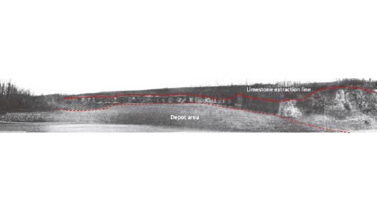
Parcel 1988, located in the canton of Baselland, Switzerland, and owned by the construction company RUEPP AG, spans 14,810 square meters. Historically, the site was used for limestone extraction and the deposition of construction materials such as gravel, leading to significant environmental impacts as shown in Figure 1. The sketch presents a detailed profile of the extraction site, captured from the road, highlighting the significant disruption caused by the extraction activities, with a clear demarcation of approximately 40 meters along the hill. The extraction line at the top of the hill is distinctly visible, marking the boundary where the natural landscape was altered. Additionally, the depot area is prominently featured in the foreground, stretching almost the entire length of the site. This area, used extensively for the storage and deposition of construction materials, vividly illustrates the scale of the environmental disturbance. This visual overview sets the stage for a more detailed examination of the site. The aerial imagery reveals the extent of the environmental impact across the entire parcel and marks discontinuity in the forest, extending from the northern to the southern ends of the parcel. These images underscore the significant ecological disruption caused by the limestone extraction and material deposition, which are critical considerations for the planning and implementation of restoration activities.
Following the creation of detailed maps, Parcel 1988 was strategically subdivided into manageable sectors and sub-sectors based on natural boundaries and notable landmarks identified from the high-resolution drone imagery (Figure 2). This approach eliminated the necessity for GPS coordinates due to the parcel's relatively small size, yet provided an efficient framework for organizing the restoration process. By segmenting the area into distinct zones, each with its own unique environmental attributes, the restoration team ensured that monitoring and management efforts could be precisely targeted.
Parcel overview and subdivision
Parcel 1988, bordered by agricultural fields (Parcel 1945) to the west, a cantonal road (Parcel 1783) to the east, and forested areas to the south (Parcel 1991) and north (Parcel 1944), holds significant ecological importance. Notably, Parcel 1944 has been designated as a communal protection area due to its ecological significance, featuring a permanent resurgence source of water that is particularly active during rainy periods. This water source supports the dense vegetation shared by both Parcel 1944 and the adjacent North Forest in Parcel 1988. These two areas form a contiguous block of forest with minimal ecological boundaries, enhancing the North Forest's role as a critical wildlife corridor. This corridor facilitates movement between Parcel 1944 and various parts of Parcel 1988, while also connecting to the eastern part of the farmer's field and the unpaved road in Parcel 1945. The ecological connectivity provided by the North Forest significantly enhances its value, making it a focal point for conservation and restoration efforts.
Similarly, the South Forest, though differing slightly due to microhabitat variations, plays an equally crucial role in maintaining biodiversity. It extends this connectivity by linking the forested areas of Parcel 1988 to the eastern edge of the farmer's field and the unpaved road in Parcel 1945. Together, the North and South Forests contribute substantially to the ecological network within and beyond Parcel 1988, underscoring their importance in the overall restoration strategy.
Detailed sector and sub-sector division
Based on the drone imagery, Parcel 1988 was divided into several sectors and sub-sectors, each characterized by its unique environmental attributes:
- Sector A (Amphibian): This sector encompasses sub-sectors A1 and A2, which consist of artificial pools created as part of the renaturation efforts to attract and support amphibian populations. These pools are characterized by the absence of surrounding vegetation and are enclosed by the cliffs of the plateau, the North Forest, and are situated close to the road. This positioning creates an almost secluded environment, making the pools a critical component of the early stages of restoration. Monitoring efforts in this sector focus on evaluating the success of these pools in attracting amphibians and other wildlife, considering their unique, enclaved setting. The strategic location of these pools and their implications for amphibian populations will be further discussed in the discussion section.
- Sector F (Forest): This sector includes the North, Middle, and South Forests:
- North Forest: Intrinsically connected to Parcel 1944, this forest area serves as a vital wildlife corridor, enhancing movement and ecological interaction between Parcel 1944 and various parts of Parcel 1988. It also connects to the eastern sections of Parcel 1945, further integrating the broader landscape.
- Middle Forest: This sub-sector is characterized by a rich diversity of bird and small mammal species, playing a crucial role in the site's overall biodiversity. The area supports a variety of habitats and is a key focus for conservation efforts aimed at sustaining these populations.
- South Forest: While similar to the North Forest, this area shows slight variations in species composition due to differences in microhabitats. It further extends the ecological connectivity within Parcel 1988 and serves as a critical linkage to Parcel 1945.
- Sector R (Reptile Zones): This sector is divided into:
- R1: A smaller, shaded rock-fall talus area, which, due to its specific conditions, is identified as a potential habitat for reptiles. Although less exposed to sunlight, this area requires careful monitoring to assess its suitability for reptile populations.
- R2: A larger, more exposed rocky zone that has been identified as a high-potential reptile habitat through an official ecological analysis. This sub-sector is particularly important for monitoring reptile activity, which is conducted through regular direct observations and the use of fixed cameras. Despite the challenges posed by the Suntekcam HC940 cameras in detecting cold-blooded animals under varying conditions, this area remains a key focus for herpetofaunal studies.
- Sector S (Street): This sector includes:
- As (Asphalt): A transition zone adjacent to a small access road, this area is notable for the water infiltration observed during rainy days, which could have implications for the surrounding vegetation and soil stability.
- PI1 (Plateau 1) and PI2 (Plateau 2): These plateaus serve as transition zones along the parcel's inner roads. During periods of strong rain, these areas exhibit significant water runoff and infiltration. Geological observations indicate that the rocks in these zones are primarily limestone, which contributes to surface erosion and water infiltration at the extraction site. The ground at the top of the extraction site is more prone to erosion compared to deeper layers, where the ground is more compact. In contrast, the ground in PI1 and PI2 is compact, preventing water passage and causing water to accumulate. This water retention creates a high-humidity environment, making these plateaus particularly interesting for amphibian habitats and plant species that thrive in moist conditions.
- Ruderal Zone: This zone, likely corresponding to the former depot area, is characterized by disturbed soils and opportunistic vegetation. The hydrogeology of the Ruderal Zone has been significantly altered, largely due to the disrupted infiltration patterns observed in PI1 and PI2, where the compacted ground prevents water from seeping into the deeper layers below. As a result, water that would typically infiltrate and drain into this zone is instead retained in the plateaus above, exacerbating the disturbed conditions of the Ruderal Zone. The area was methodically divided into a grid of 8 rows of 4×4 meter quadrants for extensive plant data collection. Additionally, a sporadic and random sampling method was employed to capture the diversity of early successional species more quickly. Restoration efforts in this zone focus on stabilizing the soil and promoting the development of more diverse and stable plant communities.
Note. Herpetofaunal studies refer to the scientific research and study of amphibians and reptiles, collectively known as herpetofauna. The term “herpetofauna” comes from the Greek words “herpeton,” meaning “creeping animal” and used to refer to reptiles and amphibians, and “fauna,” meaning “animal life.”
The Ruderal Zone, in particular, exemplified the innovative and adaptive methodologies developed within this study. The unique grid-based sampling approach, followed by sporadic and random sampling, allowed for efficient data collection and provided a comprehensive overview of plant species presence across the zone. This method proved especially effective in smaller zones, where precise data extrapolation is critical for understanding ecological dynamics. The study's approach ensured that even dynamic and transitional environments, which are often challenging to monitor, were effectively studied and managed. This level of detailed and adaptive monitoring is essential for informing the ongoing restoration efforts and ensuring the long-term ecological recovery of Parcel 1988. This approach, focused on specific environmental attributes and adaptive monitoring, establishes a robust framework for ongoing conservation and provides critical insights into ecological restoration within complex, post-industrial landscapes like quarries. The findings from this study are expected to contribute valuable knowledge and methodologies to the broader field of ecological restoration, particularly in enhancing biodiversity and ecological resilience in degraded environments.
Strategic importance and restoration implications
The detailed identification and subdivision of these sectors not only structured the data collection process but also enabled a more targeted and effective approach to monitoring and analyzing the site's ecological conditions. Each sub-sector was chosen based on its distinct environmental characteristics, which are crucial in determining the types of species inhabiting those areas. This structured approach allows for a nuanced understanding of the site's ecology, informing the restoration strategy and ensuring that efforts are tailored to the specific needs and potentials of each area.
2. Observational data collection
Following the completion of site mapping and the establishment of distinct ecological sub-sectors, the study progressed into a comprehensive observational data collection phase. This phase was characterized by a systematic and integrative approach to monitoring species across the entire ecosystem, aiming to provide a holistic view of the site's ecological health. Over a three-month period, more than 100 observations were meticulously recorded, capturing a wide range of species and behaviors. Unlike traditional studies that focus on specific taxa, this integrative approach was designed to gather data across the entire ecosystem, offering a comprehensive understanding of the site's biodiversity, species abundance, and ecological dynamics.
The observational data collection phase built upon the foundational work of site mapping and subdivision, with the primary objective of assessing the ecological health of Parcel 1988 through detailed, cross-taxa observations. Each observation was systematically documented in Excel, with meticulous entries that included species identification, sub-sector locations, observed behaviors, and the conservation status of each species. This method ensured that the data collected was both comprehensive and precise, allowing for detailed analysis in subsequent phases of the study.
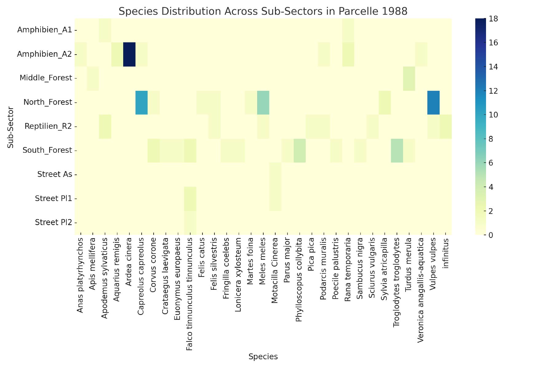
The heatmap reveals significant variability in species distribution across the sub-sectors. For example, sub-sectors such as Amphibian_A2 and North_Forest host higher concentrations of species like Corvus corone (Carrion Crow) and Turdus merula (Common Blackbird). In contrast, sub-sectors such as Amphibian_A1 and Reptile_R2 exhibit fewer species, which may indicate lower biodiversity in these areas or fewer observational opportunities. This information is critical for identifying areas within Parcel 1988 that may require more focused conservation efforts.
The findings from this observational phase form the basis for a deeper analysis of biodiversity, species abundance, and trends in species richness over time. These analyses are crucial for evaluating the success of the restoration efforts and guiding future conservation strategies. By capturing data across the entire ecosystem, this integrative monitoring approach provides a robust foundation for understanding the complex ecological dynamics at play within Parcel 1988, informing ongoing and future restoration efforts.
3. Biodiversity analysis
A comprehensive biodiversity assessment was conducted using the Shannon-Wiener Index across different sub-sectors of Parcel 1988. The Shannon-Wiener Index is a widely used metric in ecological studies that accounts for both species richness, the number of different species, and species evenness, the relative abundance of each species. This index provides a nuanced understanding of the diversity and distribution of species within each sub-sector, offering valuable insights into the ecological health and resilience of the study area.
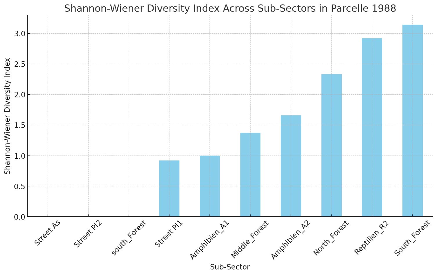
The results of the Shannon-Wiener Index highlight significant variations in biodiversity across the parcel. Sub-sectors such as South_Forest and Reptile_R2 exhibit higher diversity indices, indicating a more varied and evenly distributed range of species. These areas are likely to be ecologically balanced and resilient, making them priorities for conservation efforts. The higher biodiversity in these sub-sectors suggests robust ecological interactions and a greater capacity to withstand environmental changes.
Conversely, sub-sectors like Street_As and Street_PI2, which show lower diversity indices, may require more intensive restoration efforts to enhance habitat quality and increase species diversity. The lower diversity in these areas could be indicative of degraded habitats or limited resources, which could hamper the ecological recovery of these zones. Targeted restoration strategies, focusing on improving habitat structure and resource availability, will be critical in addressing these deficiencies.
The analysis provided by the Shannon-Wiener Index forms an essential part of the overall evaluation of the restoration efforts at Parcel 1988. By identifying areas of high and low biodiversity, this assessment helps prioritize conservation actions and informs adaptive management strategies aimed at enhancing ecological resilience across the parcel.
4. Species abundance analysis
To gain a deeper understanding of species distribution within Parcel 1988, species counts were aggregated for each sub-sector. This analysis identified areas of high and low species abundance, which is critical for pinpointing key habitats that require focused conservation efforts. By examining species abundance alongside biodiversity indices, a more comprehensive picture of the ecological dynamics within the site can be formed.
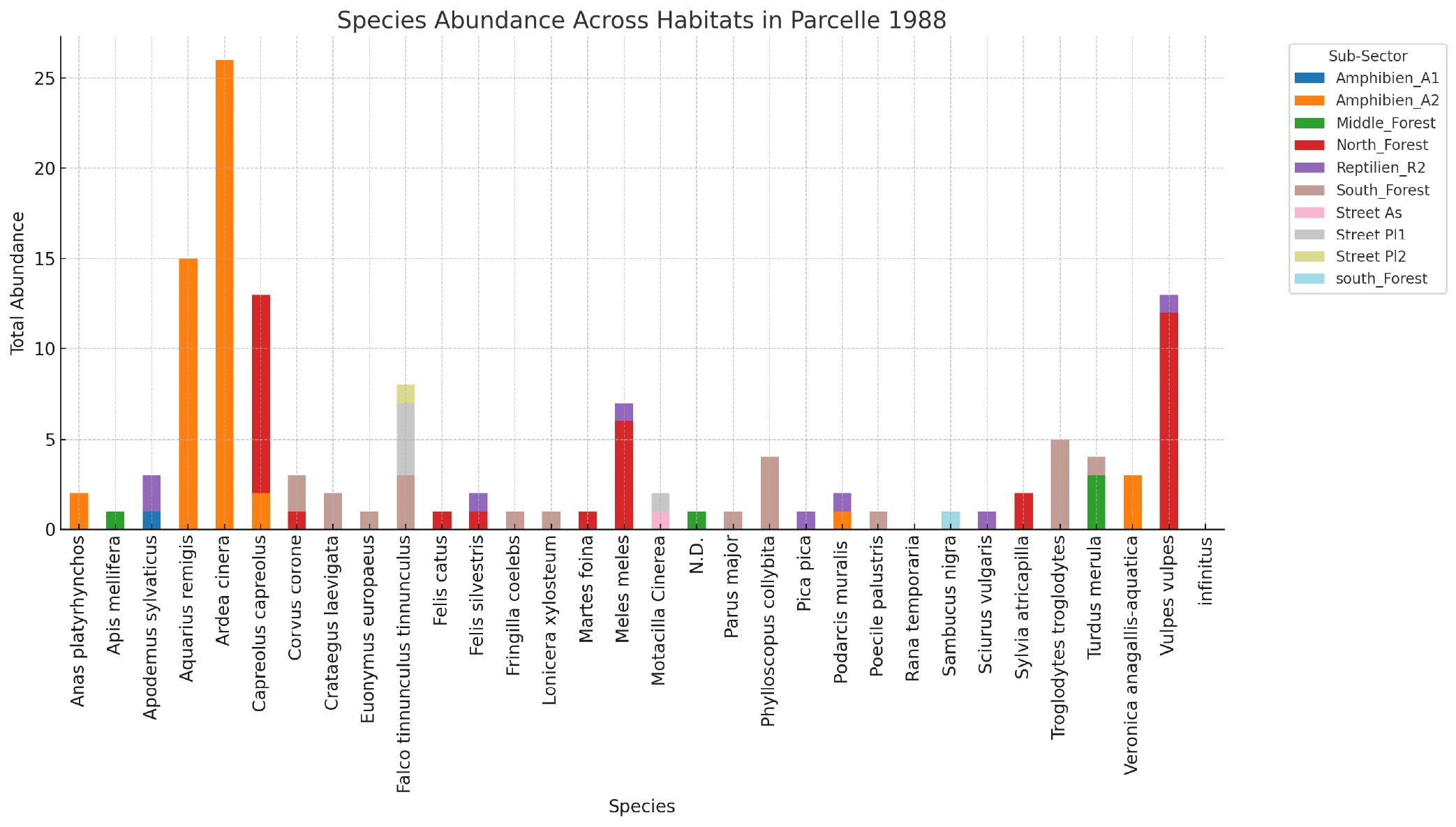
The species abundance data reveal significant variation across the sub-sectors. Notably, records associated with the Grey Heron and Capreolus capreolus (Roe Deer) indicate that specific areas provide suitable habitat conditions for these species. Other sub-sectors, including North_Forest and South_Forest, also demonstrate considerable species abundance, highlighting their importance as critical areas for conservation within the parcel.
These findings suggest that while certain habitats within Parcel 1988 are thriving and supporting robust populations of various species, other areas may require targeted interventions to enhance species populations and maintain ecological balance. Identifying sub-sectors with lower species abundance, such as those not mentioned prominently in the abundance data, is crucial for directing restoration efforts that aim to improve habitat quality and support a greater diversity of species.
The analysis of species abundance, when combined with biodiversity data, provides valuable insights into the ecological health of Parcel 1988. This comprehensive understanding is essential for guiding conservation strategies, ensuring that efforts are focused where they are most needed to foster a balanced and resilient ecosystem.
5. Trends in species richness over time
Monitoring trends in species richness over time is essential for evaluating the success of restoration efforts. By tracking fluctuations in species richness across different sectors, this analysis provides valuable insights into the dynamic nature of the ecosystem and the effectiveness of ongoing interventions.
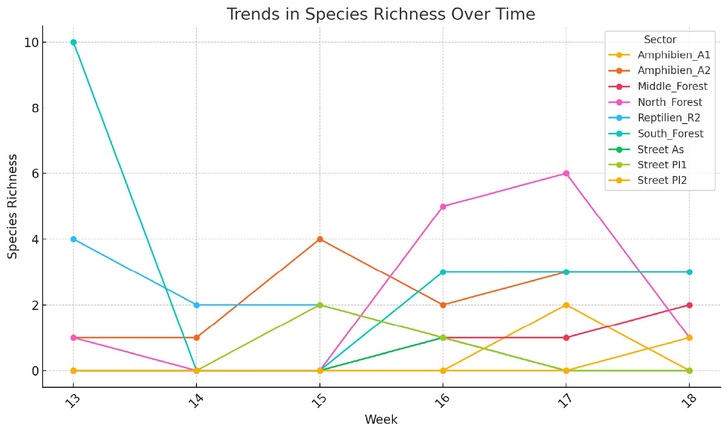
The observed trends in species richness suggest that the restoration efforts are yielding measurable impacts, although the degree of success varies by sector. In some sub-sectors, species richness is on the rise, indicating positive outcomes from the restoration activities and suggesting that these areas are becoming more ecologically stable and capable of supporting a broader range of species.
However, in sectors where species richness is either declining or showing significant fluctuations, there may be underlying ecological challenges that need to be addressed in future management plans. These challenges could include factors such as predation pressure, habitat instability, or resource scarcity, which may hinder the recovery and sustainability of species populations.
These trends in species richness serve as critical indicators of the health and resilience of the ecosystem within Parcel 1988. Continuous monitoring and adaptive management will be necessary to ensure that restoration efforts are effectively enhancing biodiversity and supporting long-term ecological recovery. By understanding the temporal dynamics of species richness, conservation strategies can be better tailored to address specific needs and challenges within each sector.
Discussion
Adaptive restoration is necessary when habitat performance is uncertain
Adaptive restoration and its necessity in complex landscapes
The restoration efforts at Parcel 1988 underscore the critical necessity of adaptive restoration approaches, particularly in complex, post-industrial landscapes like quarries. Traditional restoration practices, which often rely on standardized protocols, may not fully address the unique ecological conditions of each site. This study highlights the limitations of these conventional methods and emphasizes the importance of a flexible, data-driven approach that can adapt to the dynamic nature of degraded environments.
The subdivision of Parcel 1988 into distinct sectors based on detailed aerial mapping enabled a more targeted restoration approach. This method was crucial for addressing the specific ecological needs of each sector, whether enhancing amphibian habitats in the artificially created pools or stabilizing disturbed soils in the Ruderal Zone. The adaptive management strategies implemented in this study, including continuous monitoring of species distribution and richness, allowed for real-time adjustments to restoration efforts, ensuring alignment with the evolving ecological context of the site.
Despite significant financial investments and efforts in the amphibian zone, the absence of adult amphibians highlights the challenges and unpredictability inherent in restoration projects. Similarly, the high-potential reptile zone did not yield the expected outcomes, indicating that even well-planned interventions may not always align with ecological realities. These outcomes underscore the vital importance of adaptive restoration, which—while costly in terms of monitoring and data collection—proves financially and ecologically beneficial in the long run.
Ecological connectivity and wildlife corridors
A key finding of this study is the critical role of ecological connectivity within and beyond Parcel 1988. The North and South Forests, in particular, emerged as vital wildlife corridors facilitating species movement across different parts of the parcel and into adjacent protected areas. This connectivity is essential for maintaining biodiversity, allowing species such as badgers, deer, and foxes to migrate, find resources, and establish new populations in response to environmental changes. The observation of adult frogs in the North Forest, presumably migrating towards the artificial pools in Sector A, illustrates the importance of maintaining these corridors.
The strategic placement of the pools raises important questions about their long-term effectiveness, particularly given their proximity to the road and potential isolation by surrounding cliffs. Our analysis suggests that relocating the pools to Plateau PI1, where water infiltration already occurs and which is directly connected to the North Forest without obstacles, could enhance their effectiveness. Additionally, the current location of the pools leaves amphibians vulnerable to predators such as the Grey Heron. Measures such as planting vegetation and adding stones around the pools could provide necessary cover and protection, not only for amphibians but also for reptiles, which could use these areas as refuges from predators like falcons.
Challenges in species reintroduction and habitat suitability
The variability in species richness and abundance observed across different sectors of Parcel 1988 reflects the complex interplay between habitat suitability, species behavior, and environmental conditions. While certain areas, such as Amphibian_A2, exhibited high species abundance, others showed lower biodiversity indices, indicating potential limitations in habitat quality or resource availability.
The sporadic observation of reptiles in Sector R2, despite its designation as a high-potential reptile habitat, raises questions about the adequacy of current monitoring methods and the true suitability of this area for reptile populations. Factors such as microclimatic conditions, structural habitat characteristics, or proximity to agricultural fields, where predators like falcons were observed, may contribute to this discrepancy. While the camera traps detected reptiles, they may not have captured the full extent of reptile activity, suggesting the need for additional monitoring techniques, such as thermal imaging. However, the observed reptile activity in the Amphibian zone, which lacks adequate shelter, indicates that this area might currently be more suitable for reptiles if improved. The addition of bushes or stones in this zone could protect reptiles from predators and enhance habitat suitability.
The role of adaptive monitoring in long-term restoration success
The dynamic nature of ecological conditions at Parcel 1988, driven by factors such as natural succession, weather variability, and ongoing human activity, underscores the importance of adaptive monitoring in ensuring the long-term success of restoration efforts. The observed trends in species richness over the three-month study period highlight the complex and often unpredictable responses of ecosystems to restoration interventions.
Fluctuations in species richness in certain sectors suggest that while some restoration efforts are yielding positive results, others face unforeseen challenges. These challenges may include predation pressure, habitat instability, or resource scarcity, which require further investigation and targeted management actions. The continuous, data-driven approach employed in this study, supported by tools like the proposed NaturaSchutz DB system, provides a robust framework for addressing these challenges and ensuring that restoration efforts remain effective and sustainable.
Moreover, the success of this adaptive restoration project also highlights the significant efforts and financial resources invested in restoring Parcel 1988. The project required substantial commitment from stakeholders, including environmental experts, local authorities, and funding bodies. These investments have not only facilitated the practical implementation of adaptive restoration techniques but have also contributed to a broader understanding of the complexities involved in rehabilitating ecologically unbalanced sites. The high degree of collaboration and resource allocation underscores the importance of sustained effort and financial support in achieving long-term ecological restoration goals.
Conclusion and perspectives
Adaptive restoration should continue through monitoring, habitat improvement, and public engagement
The adaptive restoration of Parcel 1988 represents a significant advancement in the practice of ecological restoration, particularly within post-industrial landscapes. By moving beyond standardized protocols and embracing a flexible, data-driven approach, this study has successfully restored key ecological functions and enhanced biodiversity within a highly degraded landscape. This success also highlights the strong imbalance in the ecosystem that existed prior to the intervention, demonstrating the critical need for adaptive restoration methods in similar contexts.
Short-term perspectives
- Focus on the Amphibian Zone: Immediate efforts should prioritize improving the habitat around the two pools by planting vegetation and adding stones to provide cover and protection from predators like the Grey Heron. These enhancements will also benefit reptiles, offering them a safer environment within this zone.
- Nesting Boxes Installation: Installing nesting boxes for Near Threatened (NT) bird species such as falcons in the South Forest area, away from the amphibian zone, will compensate for the lack of mature forest and provide alternative nesting sites.
- Public Awareness and Protection: To mitigate the observed human activities that may be disturbing the site, for example removal of amphibians and flowers, installing informational panels around Parcel 1988 is crucial. These panels should educate the public about the ongoing restoration efforts and the importance of not interfering with the area's wildlife and vegetation.
Long-term perspectives
- Continuous Monitoring and Adaptive Management: Ongoing monitoring of the amphibian zone and other critical habitats within Parcel 1988 is essential. The implementation of the NaturaSchutz DB system will facilitate long-term data management, ensuring that restoration efforts remain responsive to changing ecological conditions.
- Development of Reptile Habitats: Over the long term, efforts should focus on enhancing the reptile habitats in Sectors R1 and R2. This includes adding more rocks, logs, and other features to create suitable microhabitats and exploring the use of thermal imaging technology for more accurate monitoring.
- Long-Term Public Engagement: Continued public engagement through educational programs, workshops, and guided tours can foster greater understanding and support for the restoration efforts at Parcel 1988. This will help secure public buy-in for ongoing conservation measures and reduce human disturbances at the site.
In conclusion, the adaptive restoration of Parcel 1988 has been a successful endeavor, offering critical insights into the complexities of restoring ecologically unbalanced landscapes. The significant efforts and financial resources invested in this project have not only led to tangible ecological improvements but also laid the groundwork for future restoration projects. The study further demonstrated the importance of adaptive restoration approaches, which, despite their cost, are ultimately more efficient and financially beneficial. To support ongoing and future projects, we propose developing a specialized tool called NaturaSchutz DB. This tool will integrate adaptive renaturation data management, guiding users through relevant statistical analyses and providing automated protocol generation and reporting. As restoration practices continue to evolve, the principles of adaptive management and ecological connectivity will play an increasingly important role in ensuring the long-term success and sustainability of restored ecosystems.
References
Literature and technical sources supporting the case study
- Audacity Team. (2020). Audacity: Free, open-source, cross-platform audio software. Reference details to be verified.
- Brown, M., & Lowe, D. G. (2007). Automatic panoramic image stitching using invariant features. International Journal of Computer Vision. Reference details to be verified.
- Clewell, A. F., & Aronson, J. (2013). Ecological Restoration: Principles, Values, and Structure of an Emerging Profession. Island Press.
- Holling, C. S. (Ed.). (1978). Adaptive Environmental Assessment and Management. John Wiley & Sons.
- Kahl, S., Wood, C. M., Eibl, M., & Klinck, H. (2021). BirdNET: A deep learning solution for avian diversity monitoring. Reference details to be verified.
- Linnell, J. D. C., Swenson, J. E., & Andersen, R. (1997). Reference details to be verified against the citation used in the manuscript.
- Linnell, J. D. C., Swenson, J. E., & Andersen, R. (1999). Reference details to be verified against the citation used in the manuscript.
- Mäder, P., Boho, D., Rzanny, M., Seeland, M., Wittich, H. C., Deggelmann, A., & Wäldchen, J. (2021). Flora Incognita: A research platform for plant observation and identification. Reference details to be verified.
- Meek, P. D., Ballard, G. A., Fleming, P. J. S., Schaefer, M., Williams, W., & Falzon, G. (2014). Camera traps can be heard and seen by animals. Reference details to be verified.
- Ménoni, E., Schatz, B., & Bollmann, K. (2020). Reference details to be verified against the Grand Tétras citation used in the manuscript.
- RawTherapee Development Team. (2020). RawTherapee: Open-source raw image processing software. Reference details to be verified.
- SuntekCam. (2021). SuntekCam HC940 camera trap specifications. Manufacturer documentation. Reference details to be verified.
- Swiss Confederation. (2012). Swiss Biodiversity Strategy. Federal Office for the Environment. Reference details to be verified.
- Turner, D., Lucieer, A., & Watson, C. (2015). An automated technique for generating georectified mosaics from ultra-high resolution unmanned aerial vehicle imagery. Reference details to be verified.
- United Nations. (2021). United Nations Decade on Ecosystem Restoration 2021–2030. Reference details to be verified.
- Van Horn, G., & Iliff, M. (2020). Merlin Bird ID. Cornell Lab of Ornithology. Reference details to be verified.